North Yorkshire
| North Yorkshire | |
|---|---|
 |
|
| Geography | |
| Status | Ceremonial & (smaller) Non-metropolitan county |
| Origin | 1974 |
| Region | Yorkshire and the Humber (Part of the ceremonial county is in the North East Region) |
| Area - Total |
Ranked 1st 8,654 km2 (3,341 sq mi) |
| Admin HQ | Northallerton[1] |
| ISO 3166-2 | GB-NYK |
| ONS code | 36 |
| NUTS 3 | UKE22 |
| Demography | |
| Population - Total (2005) - Density - Admin. council - Admin. pop. |
Ranked 15th 1,073,200 125 /km2 (320 /sq mi) Ranked 19th 599,300 |
| Ethnicity | 97.9% White 1.0% S.Asian |
| Politics | |
 North Yorkshire County Council http://www.northyorks.gov.uk/ |
|
| Executive | Conservative |
| Members of Parliament | |
| Districts | |
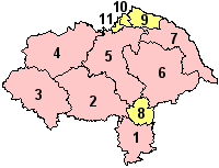
Neighbouring counties are: County Durham, East Riding of Yorkshire, Cumbria, Lancashire, South Yorkshire and West Yorkshire |
|
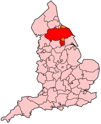
North Yorkshire is a non-metropolitan or shire county, located in the Yorkshire and the Humber region of England, and a ceremonial county in that region and also partly in North East England. Created in 1974 by the Local Government Act 1972[2] it covers an area of 8,654 square kilometres (3,341 sq mi), making it the largest ceremonial county in England. The majority of the Yorkshire Dales and all of the North York Moors lie within North Yorkshire's boundaries, and around 40% of the county is covered by National Parks.
Contents |
Divisions and environs
The area under the control of the county council, or shire county, is divided into a number of local government districts; they are Craven, Hambleton, Harrogate, Richmondshire, Ryedale, Scarborough and Selby.[3]
The Department for Communities and Local Government did consider reorganising North Yorkshire County Council's administrative structure by abolishing the seven district councils and the county council to create a North Yorkshire unitary authority. The changes were planned to be implemented no later than 1 April 2009.[4][5] This was rejected on 25 July 2007 so the County Council and District Council structure will remain.[6]
The largest settlement in the administrative county is Harrogate, while in the ceremonial county it is York.
York, Middlesbrough and Redcar and Cleveland are unitary authority boroughs which form part of the ceremonial county for various functions such as the Lord Lieutenant of North Yorkshire, but do not come under county council control. Uniquely for a district in England, Stockton-on-Tees is split between North Yorkshire and County Durham for this purpose. Middlesbrough, Stockton-on-Tees, and Redcar and Cleveland boroughs form part of the North East England region.[7]
The ceremonial county area, including the unitary authorities, borders East Riding of Yorkshire, South Yorkshire, West Yorkshire, Lancashire, Cumbria and County Durham.
Physical features
The geology of North Yorkshire is closely reflected in its landscape. Within the county are the North York Moors and most of the Yorkshire Dales; two of eleven areas of countryside within England and Wales to be officially designated as national parks. Between the North York Moors in the east and the Pennine Hills in the west lie the Vales of Mowbray and York. The Tees Lowlands lie to the north of the North York Moors and the Vale of Pickering lies to the south. Its eastern border is the North sea coast. The highest point is Whernside, on the Cumbrian border, at 736 metres (2,415 ft).[8] The three major rivers in the county are the River Swale, River Ure and the River Tees. The Swale and the Ure form the River Ouse which flows through York and into the Humber estuary. The Tees forms the border between North Yorkshire and County Durham and flows from upper Teesdale to Middlesbrough and Stockton and to the coast.
History
North Yorkshire was formed on 1 April 1974 as a result of the Local Government Act 1972, and covers most of the lands of the historic North Riding, as well as the northern half of the West Riding, the northern and eastern fringes of the East Riding of Yorkshire and the former county borough of York.
York became a unitary authority independent of North Yorkshire on 1 April 1996,[9] and at the same time Middlesbrough, Redcar and Cleveland and areas of Stockton-on-Tees south of the river became part of North Yorkshire for ceremonial purposes, having been part of Cleveland from 1974 to 1996.
Governance
North Yorkshire is a non-metropolitan county that operates a cabinet-style council.[10] The full council of 72 elects a council leader, who in turn appoints up to 9 more councillors to form the executive cabinet. The cabinet is responsible for making decisions in the County.
Economy
This is a chart of trend of regional gross value added for North Yorkshire at current basic prices with figures in millions of British Pounds Sterling.[11]
| Year | Regional Gross Value Added[12] | Agriculture[13] | Industry[14] | Services[15] |
|---|---|---|---|---|
| 1995 | 7,278 | 478 | 2,181 | 4,618 |
| 2000 | 9,570 | 354 | 2,549 | 6,667 |
| 2003 | 11,695 | 390 | 3,025 | 8,281 |
Education
North Yorkshire LEA has a mostly comprehensive education system with 42 state schools secondary (not including sixth form colleges) and 12 independent schools.
Towns and villages
Italicised locations lie outside the current North Yorkshire shire county.
- Ampleforth, Appleton-le-Moors
- Bedale, Bolton-on-Swale, Boroughbridge, Borrowby (Hambleton), Borrowby (Scarborough), Brompton (Hambleton), Brotton, Buckden
- Castleton, Catterick, Catterick Garrison, Cawood, Clapham, Conistone
- Dalton (Hambleton), Dalton (Richmondshire), Danby Wiske
- Easby (Hambleton), Easingwold, Egton, Eston, Ebberston
- Filey, Folkton, Flixton, North Yorkshire
- Giggleswick, Glasshouses, Goathland, Grangetown, Grassington, Great Ayton, Grosmont, Guisborough, Ganton
- Harrogate, Hawes, Hebden, Helmsley, High Bentham, Horton in Ribblesdale, Hunmanby, Huntington
- Ingleton
- Kettlewell, Kilnsey, Kirkbymoorside, Knaresborough
- Leyburn
- Malham, Malton, Masham, Marske-by-the-Sea, Middleham, Middlesbrough, Middleton, Ryedale, Muston
- New Marske, Normanby, Northallerton, Norton-on-Derwent, North Grimston,
- Osmotherley, Ormesby
- Pateley Bridge, Pickering
- Redcar, Reeth, Richmond, Rievaulx, Ripon, Robin Hood's Bay, Romanby
- Saltburn, Scarborough, Scorton, Selby, Settle, Sherburn-in-Elmet, Sheriff Hutton, Skelton, Skipton, South Bank, Sowerby, Stokesley, Streetlam, Sutton-under-Whitestonecliffe, Swinton, near Malton, Scagglethorpe, Scampston,
- Tadcaster, Teesville, Thirsk, Thornaby-on-Tees
- Whitby, Westow, Wintringham
- Yarm, York, Yedingham
Places of interest
Italicised locations lie outside the current North Yorkshire shire county.

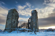
- Ampleforth College
- Beningbrough Hall
- Bolton Abbey
- Bolton Castle
- Brimham Rocks
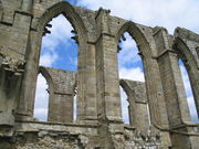
- Byland Abbey - English Heritage (EH)
- Castle Howard and the Howardian Hills
- Catterick Garrison
- Cleveland Hills
- Drax
- Duncombe Park - stately home
- Embsay & Bolton Abbey Steam Railway
- Eston Nab
- Falconry
- Flamingo Land Theme Park and Zoo
- Fountains Abbey
- Gisborough Priory
- Helmsley Castle - EH
- Ingleborough Cave - show cave
- Kirkham Priory
- Lightwater Valley
- Malham Cove
- Middleham Castle
- Mount Grace Priory - EH
- North Yorkshire Moors Railway
- Ormesby Hall - Palladian Mansion
- Richmond Castle
- Rievaulx Abbey - EH
- Ripon Cathedral
- Selby Abbey
- Scarborough Castle - EH
- Shandy Hall - stately home
- Skipton Castle
- Stanwick Iron Age Fortifications - EH
- Studley Royal Park
- Stump Cross Caverns - show cave
- Thornborough Henges
- Wharram Percy
- Whitby Abbey
- York Minster
- Yorkshire Air Museum
News and media
The County is served by BBC North East and Cumbria, and for more southerly parts of the county BBC Yorkshire. Yorkshire Television and Tyne Tees Television are also received in most areas of the County. BBC Tees is broadcast to northern parts of the county, whist BBC Radio York is broadcast more widely. BBC Radio Leeds is broadcast to southern parts of the county.
Transport
There are two main motorways that run through North Yorkshire and they are the A1(M) and the A66(M). A small stretch of the M62 motorway also runs through North Yorkshire, close to Eggborough.[3] The other main non-motorway routes are the A1, the A19 and the A66.
The East Coast Main Line, bisects the county stopping at Darlington and York. It is operated by East Coast, First TransPennine Express and Grand Central. First TransPennine Express also run the majority of services on the York to Scarborough Line with services originating from Liverpool Lime Street or Leeds City station. Northern Rail operate the remaining lines in the county including commuter services on the Harrogate Line, Airedale Line and York & Selby Lines, of which the former two are covered by the Metro ticketing area. Remaining branch lines operated by Northern include the Yorkshire Coast Line from Scarborough to Hull, the Tees Valley Line from Darlington to Saltburn and the Esk Valley Line from Middlesbrough to Whitby. Last but certainly not least, the Settle-Carlisle Line runs through the far west of the county with services again operated by Northern. The county suffered very badly under the Beeching cuts of the 1960s which saw places like Richmond, Ripon, Tadcaster, Helmsley, Pickering and the Wensleydale communities wiped from the railway map. Other notable closures were the Whitby to Scarborough, York to Driffield and the secondary main line between Northallerton and Harrogate via Ripon. The Malton to Whitby line which closed in 1965 was reopened by preservationists between Pickering and Grosmont in 1973 to form what we now know as the North Yorkshire Moors Railway. The Wensleydale Railway is another success story with plans to fully reinstate the link between Northallerton and Garsdale on the Settle - Carlisle line which ran through Hawes. The line presently operates services between Leeming Bar and Redmire but they hope to be able to access Northallerton station, on the busy East Coast Main Line, as soon as an agreement can be made with the railway authorities. Another notable reinstatement project in the county is a plan to reopen the Harrogate - Ripon line. York is the largest station in the county with 11 platforms and is a major tourist attraction in its own right. The station is immediately adjacent to the world famous National Railway Museum.
Bus services also run daily; most are controlled by Arriva, Harrogate & District, Scarborough & District, Yorkshire Coastliner, First and the local Dales & District. In York, FirstGroup run a park and ride service as well as normal bus routes around the city. There are no major airports in the county itself but Durham Tees Valley in County Durham, Newcastle Airport and Leeds Bradford International Airport are the closest.
Sports
North Yorkshire is home to several football clubs, the most successful of which is Middlesbrough FC who play in the Coca-Cola Championship; others include York City FC who have played in the Football League but today play in the Conference National. Whitby Town FC have reached the FA cup first round seven times, and have played the likes of Hull City, Wigan and Plymouth Argyle , they currently play in the Unibond Premier league. No notable rugby union teams hail from the county but York City Knights are a rugby league team and play in the Rugby League National League 2. North Yorkshire is home to many racecourses; these include Catterick Bridge, Redcar, Ripon and Thirsk. It also has one motor racing circuit, Croft Circuit; the circuit holds meetings of the British Touring Car Championship, British Superbike and Pickup Truck Racing race series. Yorkshire County Cricket Club, play a number of fixtures at North Marine Road, Scarborough.
References
- ↑ "North Yorkshire County Council : Contact us". www.northyorks.gov.uk. http://www.northyorks.gov.uk/index.aspx?articleid=42. Retrieved 2009-05-16.
- ↑ Arnold-Baker, C., Local Government Act 1972, (1973)
- ↑ 3.0 3.1 "Transport map of shire county divided into districts" (PDF). North Yorkshire County Council. http://www.northyorks.gov.uk/CHttpHandler.ashx?id=514&p=0. Retrieved 2008-10-10.
- ↑ "New council for North Yorkshire". North Yorkshire County Council. http://www.northyorks.gov.uk/public/site/NYCC/menuitem.72980bf1db3dfb9fd7428f1040008a0c/?vgnextoid=cfa68f0788110110VgnVCM100000420f1cacRCRD.
- ↑ "Proposals for future unitary structures: Stakeholder consultation" (PDF). Communities and Local Government. http://www.communities.gov.uk/documents/localgovernment/pdf/322770.pdf. Retrieved 2008-10-10.
- ↑ "Decision letter: North Yorkshire County Council" (PDF). Communities and Local Government. http://www.communities.gov.uk/pub/59/DecisionletterNorthYorkshireCountyCouncil_id1512059.pdf.
- ↑ North East Assembly - List of local authorities and members
- ↑ http://bubl.ac.uk/org/tacit/marilyns/chapter6.htm
- ↑ OPSI - The North Yorkshire (District of York) (Structural and Boundary Changes) Order 1995
- ↑ "North Yorkshire County Council Constitution". North Yorkshire County Council. http://www.northyorks.gov.uk/CHttpHandler.ashx?id=1990&p=0. Retrieved 10 May 2010.
- ↑ "Regional Gross Value Added" (PDF). Office for National Statistics. 2005-12-21. pp. 240–253. http://www.statistics.gov.uk/downloads/theme_economy/RegionalGVA.pdf. Retrieved 2008-10-06.
- ↑ Components may not sum to totals due to rounding
- ↑ includes hunting and forestry
- ↑ includes energy and construction
- ↑ includes financial intermediation services indirectly measured
External links
- North Yorkshire Guide Guide from NorthYorks.com
- BBC North Yorkshire North Yorkshire features, videos and pictures from the BBC
- Yorkshire Dales Rivers Trust
- North Yorkshire at the Open Directory Project
|
||||||||||||||||||||
|
||||||||||||||||||||
|
|||||
|
|||||